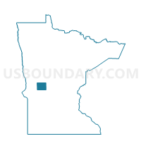
Forada Voting District, Douglas County, Minnesota
About
Outline

Summary
| Unique Area Identifier | 601881 |
| Name | Forada Voting District |
| County | Douglas County |
| State | Minnesota |
| Area (square miles) | 0.55 |
| Land Area (square miles) | 0.54 |
| Water Area (square miles) | 0.01 |
| % of Land Area | 98.83 |
| % of Water Area | 1.17 |
| Latitude of the Internal Point | 45.78873600 |
| Longtitude of the Internal Point | -95.35684560 |
Maps

Graphs
Select a template below for downloading or customizing gragh for Forada Voting District, Douglas County, Minnesota